

We’ve already begun discussing issues relevant to the Basin, particularly through blog posts … but this time we’re going back to basics. Core objects of our constitution include:
- To work for the general improvement of the urban environment.
- To promote a true understanding of Architecture and Design amongst the community.
- To consider, critique and recommend changes of law and administration relating to or affecting architecture and urban planning.
Our published Basin Checklist was put together by the committee prior to the release of the NZTA proposal, as a means by which we might objectively test any proposals for the Basin. So how does the NZTA Proposal A around the Basin (let’s save the tunnel and Ruahine St for later) measure up?

1) Does there need to be a scheme?
– Why is the scheme being proposed and what is the evidence to support this need?
– Are there “non-physical” ways to address any needs (e.g. congestion charging?)
It could well be argued that this scheme would have made sense half a century ago in the context of climate change, but there is another issue to consider. This is not to say that there is a simple need for a scheme in terms of State Highway I. The NZTA proposal states an assumption that State Highway traffic will increase by 80% by 2026 (p. 16), though this appears to contradict NZTA figures which have documented a plateau in State Highway use since the mid-2000s. The Basin though does need help on so many levels (in relation to cycle, pedestrian, and public transport), as well as in terms of urban design that something should be done. The Basin is a gateway to both the city, and to the Adelaide Rd precinct. If Adelaide Rd is to function as a growth node in the Transport Spine, the Basin needs rethinking. Some scheme is needed.
2) Does the scheme improve transportation in its broadest sense, and in a way which is appropriate for the future?
– Does the scheme improve existing access and safety into and across the Basin for cyclists (commuter and recreational), pedestrians (commuter and recreational) and public transport?
The scheme assumes that public transport is provided “between the Railway Station and Newtown” (p. 5). We believe that there is a real need for dedicated public transport to be built into the roading network out to the airport (via Newtown), which can give us the option of light rail in future. Without a link to the airport it is doubtful that light rail would warrant the cost. The Proposed Wellington Regional Public Transport Plan 2011-2021 diagram seems to suggest the airport route would bypass Newtown.

The fact there is a dedicated bus lane is a good start though for public transport, but the bus-lane is badly planned and broken in three places (even if bus priority signals mitigate some of these issues). The support for pedestrians and cyclists is poor. The proposal that the bus lane is a bike lane is also naive. Cyclists will get killed, if not by buses, by conflicts with car traffic at the three points where the bus/bike lane breaks. The scheme needs a dedicated cycle lane. The fact that a key point of the consultation is to determine whether or not to accommodate cyclists and pedestrian traffic on the overpass with an add-on “pedestrian and cycle facility” (p. 5), points directly to the clip-on nature of how the scheme considers pedestrian and cycle traffic.

The pedestrian experience though is probably not too different to the existing scheme, although hopefully detailed design work would provide a more pleasant environment. A question remains regarding whether or not there is a need to reduce the capacity for cars around the Basin, given that SH1 traffic has been diverted. This would enable better accommodation for cyclists, and no doubt create safer road conditions for all users. More lanes and wider lanes would appear to decrease cycle safety. For example, Schramm and Rakotonirainy’s article “The effect of road lane width on cyclist safety in urban areas” suggests that excess capacity encourages higher speed and risker driving behaviour. They cite one study which “demonstrated that [with] an increase in lane width by 1m, speeds are predicted to increase by 15kph … [When] the operating lane width was 2.5m, 1 m narrower than the guidelines … mean speed was found to be significantly reduced” (p. 422). They also note that “investigation has also shown that the total number of lanes also influences driver speed. Research has found that speed increases as the number of lanes increases” (p. 422)
– Does the scheme elegantly integrate state highway and local traffic flows?
The scheme enables unimpeded E-W traffic (from Mt Vic tunnel to the Bypass), though this road appears to be designed for a speed greater than 50km/hr, and why does the tunnel have a different speed limit (of 60km/hr) (p. 10)? Won’t this set up problems at the Basin? Regarding elegance and integration, in plan the state highway has a purity in geometry and purpose, while the local roading network largely perpetrates the existing aesethetic sins of its dreary environment.
– Does the scheme provide dedicated busways designed in such a way that they can accommodate light rail in the future?
It’s good that dedicated bus ways are included but the bus-lane crosses intersections in an unhelpful way, requiring buses to jump across two lanes while turning a corner from Adelaide Rd. During peak hour traffic this can’t be helpful even for a super-light rail.

– Is the scheme sensible in the context of global warming, climate change, peak oil and peak car?
The one benefit is the potential for consistent speed for state highway traffic. Less braking and accelerating reduces petrol consumption, noise and air pollution, but the scheme largely appears to address these issues at a tokenist level – but hey, the main aim is to super state highway the Basin – that’s hardly mainstream climate change mitigation …
3) Does the scheme provide a better environment for the neighbourhood (e.g. schools in the area/Government House)?
– Is it safer for school students to walk, ride and take public transport to school?
We’ll save the impact of losing much of Paterson St on Wellington Girls for the Mt Vic tunnel discussion. Reduced traffic around the Basin should make it easier for school students to access the schools, and it appears that good provision is made for school buses etc. on Dufferin St. As noted above there are no real improvements for commuter cyclists, and this is the category school student cyclists also fit into. They will need to take advantage of traffic signals and changing identities from cyclists to pedestrians and back again. Pedestrian access from Kent/Cambridge Terraces is improved.

– Does the scheme provide a better environment for children’s learning in terms of pollution and noise?
In relation to the schools these are probably no worse than currently, while those at Mt Cook school might not fare as well as the school, although further from the mighty overpass, will suffer from their proximity to the Memorial Park highway.
– Does the scheme improve access to the recreational spaces of the Basin reserve?
This appears to be similar to the existing. It is likely that spaces immediately adjacent to the Basin will have higher quality landscaping.
– Does it provide better quality of open spaces?
Not really, the only hope is the extension of the Memorial Park. The scheme provides for additional green spaces. There is no indication that these green spaces will contribute to drawing additional people to the area, as they appear to be passive rather than active in nature. The impact of the overpass on the quality and viability of the green spaces is difficult to ascertain.

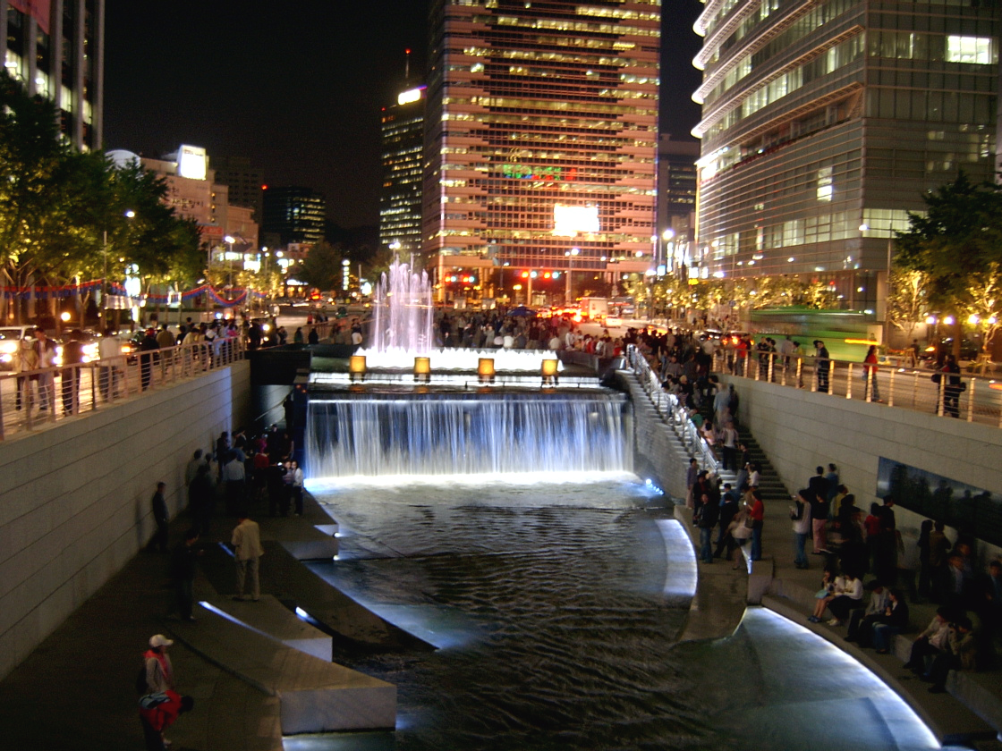
There have been successful inner city parks (e.g. Ira Keller Waterfall/Forecourt Fountain (1970), Portland, Oregon and Cheonggyecheon, Seoul (2005)), but the environment which sustains these often high density/urban rather than edging on suburban. A related question is whether the proposal benefits Memorial Park. The answer to this comes down to whether you think 40,000 cars passing a war memorial is appropriate. The pros are that the traffic will add to the level of activity and that some important memorials are placed in highly visible traffic laden spaces. The highway will be closed on important days such as Anzac Day. The cons are noise, pollution, the idea that 40,000 and a respectful, quiet, solemn space are not a good match.
– Does the scheme engage Government House as an important part of Wellington as a capital city?
The existing relationship with Government House is retained.
4) Does the scheme support the aims of the Urban Design Protocol and city council initiatives for adjacent areas?
– Is the scheme an example of excellent urban design?
This is an issues very much up for debate as the drawings are not ones which will represent the final developed design of the structures. As depicted they are quite dreary, and do not disuade conventional concerns about overpasses, which usually sever parts of cities and create negative impacts in adjacent areas. A big issue though is that the scale of this structure will overwhelm the area.

This is not a dense highly built up area of highrises, such as Manhattan, which can sustain mamoth infrastructure, which contributes positively to the grain of the urban fabric. This area is more delicate, and any design needs to reflect this. A structure which is 8m+ high and 12m (without cycle/pedestrian “facilties”) is a giant in this landscape. It would have to be designed incredibly well to offset these issues – and the images given aren’t of compelling design.
The Urban Design Protocol advocates the seven Cs: Context, Character, Choice, Connections, Creativity, Custodianship, Collaboration. Issues of Context and Character have been largely discussed above, they centre around the scale of the urban form of largely low-rise buildings and shifting grains of urban fabric (Mt Vic c.f. Mt Cook c.f the city), but also here, the fact that the Basin is situated within a street grid deformed by the landform. The site is also situated within a N/S valley, through which a stream (still) runs. It is debateable whether the proposal addresses this context and character in any meaningful way.
Choice means building diversity into the fabric. The provision for future light rail is important. The potential for greenspaces to be passive and active are other examples. The scheme does little to enhance issues of choice.
Connections is a key question to which the design of the overpass will be critical. Does the overpass create severance between Adelaide Rd and the city? or does its design eliminate dark residual spaces and create new opportunities and identity for this dreary part of town? The proposal appears to sever the city from Newtown and Mt Cook, and compromise the well defined edge of Mount Victoria.
Creativity is about innovative thinking about the environment. The scheme leaves as much as possible intact and hoists a great hooting 380m of car traffic in the air. Yes it’s retro – but hardly innovative. An innovative proposal would be more challenging, and would draw us into a conversation about the kind of places we would live to live in.
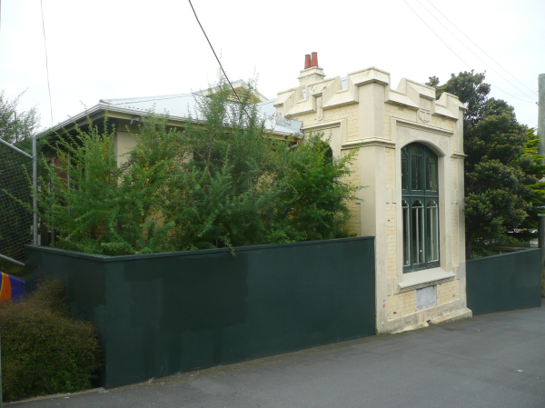
Custodianship refers to how the scheme operates in terms of kaitiakitanga. Does the scheme protect ecological and built heritage? How does it reduce our negative impacts on the planet? A scheme that is really about car-worship is not likely to sit high in this category. The John Swan creche is removed – but no indication of where to – issues of orientation and use are important to whether this re-siting is viable. As a Category I historic place, the creche should only be moved as a last resort. The Basin too is an identified historic place. It stays intact. The street grid is an important part of this area of Wellington, as is the formal boulevard of Kent and Cambridge Terraces. The overpass does not provide an ideal termination to this procession route. The proposal will also demolish the buildings on the corner of Kent Tce and Ellice St. These buildings are not historic places, but they are the only buildings in the precinct which acknowledge the geometry of the roading.
Collaboration is what we are doing now – discussing it, debating it, ensuring the best solution is the one that is built. It might mean things take longer than planned – but the community has a meaningful involvement in decision-making. Will the huge machine which is the NZTA stop long enough to take comments from the community on board, and reappraise the project?
– Is the scheme a good fit for this part of the city (e.g. its relationship to the Victorian Kent/Cambridge Tce?; the deformed city grid (deformed by its geography))?
As mentioned above the scale of the project is challenging given the scale of urban fabric. The termination of the rigid geometries of the Victorian planning of Kent/Cambridge Tces supports the geometries but does not improve the current anti-climax.
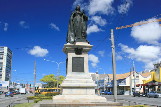
Perhaps the Queen Vic statue needs another move to help it out. The overpass tries to align with the geometry of the grid, but of course is only partially successful regarding this.
– Does the scheme sit well in relation to the Adelaide Road plan, the Wellington Transport Strategy and the Ngauranga to Airport Growth/Transport Spine?
These documents support the idea of the spine from Ngauranga to the Airport, along which Adelaide Rd has been identified as a growth node. Connectivity to the city, and increased amenity (including high quality public transport) are key to the viabilty of Adelaide Rd’s development along the lines of medium density residences, and mixed-use development. The potential severance of the overpass is a problem in this context, the provision of a dedicated bus-way is positive, though as mentioned above, there are flaws in its design. The lack of meaningful provision for commuter cycling is a negative. Traffic reduction and increased accessibilty to the Basin should help to improve the amenity values of the area.
– Does the scheme support the Basin as a destination, rather than one of the world’s largest roundabouts cut off from its local community?
The reduction of traffic around the Basin, is really the only way the scheme addresses improved access to the Basin.
5) Does the proposed scheme respect existing cultural environment and add to it?
– Does the scheme respect areas of significance to local iwi?
We need more advice in order to really judge this. Historically the area was one of food gathering before the land was lifted in the earthquake. The streams which flow through the site are also important to be respected.
– Does the scheme respect the siting, or better site, historic buildings (e.g. Ettrick Cottage, Government House, John Swan’s Compassion Creche)?
The scheme relocates the Compassion Creche. How and where it is relocated will be critical to evaluating the respect or lack of it for this important heritage building. We’ll discuss Ettrick cottage later in relation to the tunnel proposal. Government House appears to be unaffected positively or negatively.
– Does the scheme respect areas of significance to local community groups (e.g. residents, sportspeople)?
Again this appears to be in the unaffected (postively or negatively) category.
– Does the proposal have well designed structures?
The images suggest an unimaginative design of the overpass, but it would be fairer to say that they are yet to be designed. How then can we (with this scheme) ensure that time and money is spent to get well-designed and considered structures?

6) Is the cost warranted? and are the benefits (e.g. social, environmental, economic) of the scheme appropriately recognised?
– What is the cost/benefit analysis and does it understand costs and benefits beyond a narrow view of traffic flow (e.g. quality urban design, health, providing better recreational spaces, encouraging pedestrian/cycling, presenting cultural/environmental aspects of the area)?
The NZTA economic benefits are largely argued in terms of roading. A better understanding of the comprehensive issues would be helpful. See the commentary on NZTA/RoNS cost/benefits.
– How does the cost benefit compare with other scenarios?
There is documented analysis within the NZTA framework for other NZTA proposals on the NZTA website but broader issues of social, environmental issues need further thinking.
7) Is Wellington a better place because of this scheme?.
Well that is for you to decide.
Be vocal.
Leave a Reply