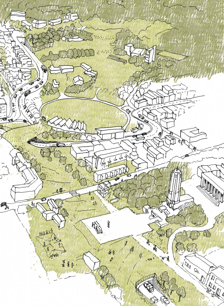
Thanks again for all your questions. We’ll up date this page to address questions as they come in, and supply new drawings etc. to explain things as needed. Here’s an initial batch of questions and answers to start with.
PUBLIC TRANSPORT
The dedicated public transport lanes (buses or light rail) are in the middle lanes. How will they be accessed?
Overseas examples show easy ways to enable pedestrian access to centrally located public transport. An example is shown in this drawing. This has the advantage that cars turning into side streets and driveways do not have to block the bus lane, and the public transport route can achieve uninterrupted speeds.
Why doesn’t the light rail go straight under the Basin Reserve?
The advice that we have received about tunnelling under the Basin is that cut and cover under the Basin is possible but likely to be difficult – not because of hard rock, but instead because of very soft, water-laden, silty soil. This may make a tunnel under the Basin rather expensive as the site is a former swamp and this means that the resulting tunnel will be subject to uplift from the surrounding groundwater. The NZTA website (http://www.nzta.govt.nz/projects/basin-reserve/publications.html) includes geotechnical reports for this area in the 2000-2001 Meritec report. The relevant bits are in this file: basin-reserve-sar-vol1-2001-geo-tech
There another comment on the Geotechnical considerations at: http://www.nzta.govt.nz/projects/basin-reserve/docs/basin-reserve-scoping-report-15-geotechnical-considerations.pdf and at: http://www.nzta.govt.nz/projects/basin-reserve/docs/basin-reserve-preliminary-geotechnical-appraisal-report.pdf
THE SOUTH-EAST QUADRANT
What is the green south-east quadrant?
The green south-east quadrant is a connecting park area (from the Basin to Government House) with driveway access to Government House and adjacent schools, as well as accommodation for buses servicing the schools. This driveway and bus turning is restricted to the south side. A pedestrian and cycle way continues the historic grid of the Basin on the eastern side. This will connect the Town Belt walkways into the inner city park through the Basin and Memorial Park.
This can be accommodated within the existing road space, or another option can be seen in the scheme below.
Where is the school drop-off for buses from the eastern suburbs?
The school drop-off for buses from the eastern suburbs is in the south-east quadrant (see above). Access is through the Mt Victoria tunnel, turning left around the Basin on Sussex St and direct from Rugby St. Access from the south-east quadrant and back to the eastern suburbs is made by turning left onto Adelaide Rd and back through Constable St.
How are Government House, the schools and apartments in the south-east quadrant accessed?
Government House, the schools, and apartments are accessed from Rugby St.
MEMORIAL PARK TUNNEL
How do buses from Newtown access the Memorial Park tunnel?
The bus lanes primarily support public transport routes. Where buses (e.g. school trips) are not following public transport routes they would be able to use other parts of the roading system. Buses from Newtown to Taranaki Street would access the Memorial Park tunnel using the local road rather than the dedicated bus lanes.
Is an uphill-sloped tunnel a good idea?
The Memorial Park tunnel would have a gradual slope. The tunnel floor at the north-west corner (Sussex and Buckle Sts corner) would be at about 6 metres above sea level. The corner of Taranaki and Vivian St is about 17 metres above sea level. This means a rise of about 11 metres over about 340 metres – giving a gradient of 1:30 or about 3%. As a comparison, the Mount Victoria tunnel has a gradient of 1:53 or about 2% (It is 634 metres long, the Paterson St entry is 23 metres above sea level; the Ruabine St entry is 35 metres above sea level). This contour information is available from the WCC at: http://www.wellington.govt.nz/maps/webmaps/webmap/wccmap.html
Where does the Memorial Park tunnel exit?
The proposal suggests that the Memorial Park tunnel exits before Taranaki St, as depicted in the bottom part of the image below.
THE NORTH-WEST CORNER
What happens to the John Swan design Compassion Creche?
An excellent question. You may have seen on the Option X pdf that detailing of the North-West corner would determine whether the creche would be located in its current position, and any relocation would be under the advice of the NZHPT. This is an important building an early purpose-built creche by a significance architect, and a last remaining remnant of the Catholic community on Buckle St. It is highly likely that the building would need to be moved during construction to prevent damage. If the creche is moved it would be moved to a location which retained its current orientation, with a street frontage.
How do the levels work at the north western corner?
Here’s a section through this area to show you.
We have developed the levels using a contour model derived from the contours available from the WCC: http://www.wellington.govt.nz/maps/webmaps/webmap/wccmap.html
TRAFFIC VOLUMES
Is one lane on Adelaide Rd enough? Is one lane from Kent Terrace to Newtown/Island Bay enough?
The number of lanes on Kent and Cambridge Terraces and Adelaide Rd in Option X is the same as the NZTA proposal: one traffic lane and one bus lane. Roughly the average daily traffic volumes on the State Highway network is 20,000 cars, and on the local roads 10,000 cars. The information on current volumes is in this pdf from the WCC (basin reserve traffic data). There is also some information about this at: http://www.nzta.govt.nz/projects/basin-reserve/docs/basin-reserve-scoping-report-06-existing-traffic.pdf
HOW MUCH WILL OPTION X COST?
The Architectural Centre have commissioned Rider Levett Bucknall to provide an independent cost for Option X. They have estimated that Option X will cost $130-165million. Option A is estimated to cost $75-100m; Option B $90-120m. The Rider Levett Bucknall draft report ccan be found here. We’ll replace this with the final report when we get it.
TRAFFIC ROUTES
How do people from the easterns suburbs access Cambridge Terrace or Tory Street?
People from the eastern suburbs can access Cambridge Terrace one of two ways. They can travel along the State Highway, which has a reduced number of intersections, to Taranaki St, or they can travel via Constable Street and Adelaide Road to access Tory St (via Rugby and Tasman Sts) or along Sussex St to Cambridge Tce.
How do cycles/pedestrians travel from east-west?
Yes this is tricky, and something which also depends to some extent on the Mount Victoria tunnel scheme. The route would be along Dufferin and Ellice Streets to Kent Terrace and then crossing at the pedestrian crossing (see Option X pdf). We agree that this isn’t completely satisfactory and are working on a better plan.
Why is there no south-to east route?
According to NZTA data (see: http://www.nzta.govt.nz/projects/basin-reserve/docs/basin-reserve-scoping-report-06-existing-traffic.pdf section6.5.1 p. 40) “Very few motorists travel between Adelaide Rd and Mount Victoria Tunnel in either direction.” They identify that 50% of traffic from Adelaide Rd goes to Cambridge Terrace and 50% goes to the Inner City Bypass.
How does traffic get from Adelaide Rd to SH1 westbound?
Car traffic from Adelaide to Taranaki St and beyond takes the slip lane into the tunnel at the current corner of Sussex Street and Buckle Street. We’ll redo the diagram to make this clearer as a couple of people have missed this.
What is the pedestrian access from Mt Victoria (Ellice St etc) into the Basin?
Yes we agree that relying on the current route (death by crossing SH1 or a detour to Kent Terrace pedestrian crossing) isn’t the best. We’ve listened to you and have decided a pedestrian overbridge is the best plan. We are doing a conceptual design which will work with the existing contours. Images soon.
What is the pedestrian route from Kent/Cambridge to Adelaide Rd?
The proposal is to have several pedestrian crossings (with traffic lights similar to the current arrangement) at the Buckle St end of Cambridge and Kent Terraces. The exact placement of these will depend on bus/light rail stops. These crossings will provide access to the green overbridge and through the Basin to Adelaide Road. The green overbridge here is important as a pedestrian crossing across SH1 doesn’t make any sense.


Leave a Reply