Since the unveiling of the NZTA schemes for around the Basin now almost a month ago, we have been having a good look at their back issues – the NZTA publications that they have been storing up away from prying eyes. Now, however, a good number of them have been published and are available on line.
One of the more interesting things unveiled, is the plan of the work for the Memorial Park. Designed, like many of the new landscapes in Wellington, by one of New Zealand’s most respected and innovative landscape architecture practices: Wraight and Associates, in association with Athfield Architects, the plans for Memorial Park have been hidden from public view until recently. The owner of the proposed Memorial Park, the Ministry of Culture and Heritage, have so far only posted a small snippet of the park design known as the Interim Park, until this whole saga of NZTA’s Basin scheme has been resolved.
In this Interim Park, now partially constructed, and shown below, a central square of limestone gravel is shown surrounded by 2 simple grassed wedges of shiny green lawn. The rest is portable planting, where “Painted linework is proposed across existing asphalt surfaces interpreting the site history.” Of far more interest however, is the plans that have been published for the full park when completed. Readers with a sharp memory may remember that a limited entry competition was run for the design of the park several years ago. So: do we know now what entry was proposed?
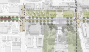
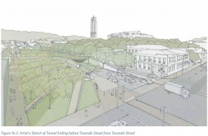
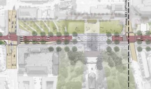
Well, to be honest – sadly, no we don’t. None of the entries were ever published – including the winning entry. But there are some clues. There are some plans for the Memorial Park that have made their way into the published information, although we’ll probably never quite know what the desired option was. What seems to have happened is that there is one Wraight / Athfield plan of a generic Park, which is then being used as a background for any / all of the NZTA options involving the State Highway running through the park. We’d like to think that this option shown here would have been the desired outcome of the Ministry of Culture and Heritage – certainly it is the only one that really respects the sanctity of the National War Memorial. The State Highway is enclosed in an underground tunnel, racing below the surface, and emerging only once it is past the intersection with Taranaki St.
As can be seen, the Interim Park solution remains at the centre of this scheme, and a series of concrete retaining walls fan out at angles in a similar way to Wraight and Associates work at Cobblestone Park and Waitangi Park. It is a striking device, mediates the land well, and copes with level changes. It would also allow members of other countries a place to build their own War Memorial, situated in quiet park-like settings near to the central NZ War Memorial and the Hall of Memories. Australia is champing at the bit to be allowed to build their memorial, before all their old Diggers die off. Sorry old boys: don’t hold your breath. We’ve got to build a few tunnels and bridges first.
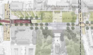
The second plan shown here is an alternative version, with the underground tunnel arriving at the surface near / just before the intersection with Taranaki St. This version, while it does take a chunk of usable land out of the Park for the tunnel exit, does still allow a harmonious relationship between the main War Memorial and the central part of the Memorial Park opposite. It also allows traffic from the State Highway to split off north or south at Taranaki St, enhancing the connectivity of the city. This is, broadly speaking, similar to what our Option X is proposing. It still allows the Park to function as a place for people to gather, to enjoy the park, to pay their respects, and to have a small amount of low speed, low volume traffic come and visit the park and the Memorial.
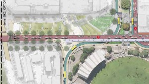
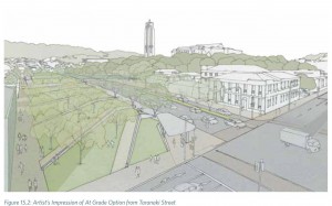
The last version is a sad looking affair, that has the State Highway running through the Park at ground level, in much the same way that it does now. The Park is thus completely sliced in two, with the NZ War Memorial on the south side, and the other countries war memorials marooned on the other side of the 30,000 cars that this road carries. As time goes by, if you believe the NZTA figures, the amount of traffic on this road will increase by up to 80% as well, so this is a permanent barrier cutting through the park like a dagger to the heart. This sliced-up Park is what the NZTA have convinced the Ministry of Culture and Heritage that it is all that can be afforded, and somehow the city and the community is lumbered with the prospect of this sorry beast.
This design should be rejected for a number of reasons. Firstly, the Park will be in two parts, with a busy State Highway racing between the two halves. Crossing in the middle will not be sanctioned – pedestrians may only cross at the controlled intersections either end, or else they risk getting run down by the speeding motorists. Indeed, the safest time to cross the road is when it is jam packed and clogged with congestion – at that time the road grinds to a halt, and the students who live and work nearby can cross between the cars with impunity. The Park becomes in effect a massive car park, not a memorial park.
At times when the cars are not sitting still however, the effectiveness of the area as a Park is severely compromised. One of the truly great and wonderful things with Wraight’s design for the Waitangi Park, is that the large space so fought for by all concerned (the public and the designers) can accommodate a number of events, a number of things to do. It is a park for the people. It can take a casual game of footie, a serious game of frisbee, a Pasifika festival or a Cirque d’Soleil tent. It can take a casual stroll with the family on a sunny Sunday, or a crowd of fired up joggers keen on doing laps. It is a place where children and small dogs can roam freely off the leash, without fear of getting spread across three lanes of traffic.
None of these things are going to happen in Memorial Park with a three-four lane State Highway cutting through the middle of it. No child is going to be left to play there, no dog to roam. No sunbathers will congregate there for a casual sunning, no events will gather at the periphery. No footie will be played, no frisbee risked so close to a major road. Lives will be risked by those who dare to cross the asphalt high speed strip. The only life the Park will have is once a year, when the traffic is brought to a halt for 4 precious hours, and dignitories can walk across the asphalt free of the chance of getting run over. Meanwhile the traffic is piling up at the Mt Vic off-ramp which is only a single lane wide, or if it does continue across the aerial flyover that NZTA proposes, the traffic will then have to be squeezed down a crowded Tory St into an unappreciative city. The rest of the year the Park will stay as a forlorn, sad sight, or even a sad site. Unvisited. Unappreciated. Unloved. And sadly, certainly, Unused.
The rest of the Park design is similarly abused by the proposals for aerial flyovers landing on the ground near Tory St. The published designs, obviously still only interim until a final plan has been allowed to emerge, show a similar array of stepped inclines making their way down the hill, in a manner not dis-similar to Chinese rice paddies, and overshadowed by the end of the flyover. Somehow, visitors to the park may be able to walk their way up through the park, next to the highway, to enjoy a picnic sandwich or two on the side of the bypass.


Leave a Reply