Thanks again for all your questions.  We’ll up date this page to address questions as they come in, and supply new drawings etc. to explain things as needed.  Here’s an initial batch of questions and answers to start with.


PUBLIC TRANSPORT

The dedicated public transport lanes (buses or light rail) are in the middle lanes.  How will they be accessed?

Overseas examples show easy ways to enable pedestrian access to centrally located public transport.  An example is shown in this drawing.  This has the advantage that cars turning into side streets and driveways do not have to block the bus lane, and the public transport route can achieve uninterrupted speeds.

Why doesn’t the light rail go straight under the Basin Reserve?

The advice that we have received about tunnelling under the Basin is that cut and cover under the Basin is possible but likely to be difficult – not because of hard rock, but instead because of very soft, water-laden, silty soil. This may make a tunnel under the Basin rather expensive as the site is a former swamp and this means that the resulting tunnel will be subject to uplift from the surrounding groundwater.  The NZTA website (http://www.nzta.govt.nz/projects/basin-reserve/publications.html) includes geotechnical reports for this area in the 2000-2001 Meritec report.  The relevant bits are in this file: basin-reserve-sar-vol1-2001-geo-tech

There another comment on the Geotechnical considerations at: http://www.nzta.govt.nz/projects/basin-reserve/docs/basin-reserve-scoping-report-15-geotechnical-considerations.pdf and at: http://www.nzta.govt.nz/projects/basin-reserve/docs/basin-reserve-preliminary-geotechnical-appraisal-report.pdf


THE SOUTH-EAST QUADRANT

What is the green south-east quadrant?

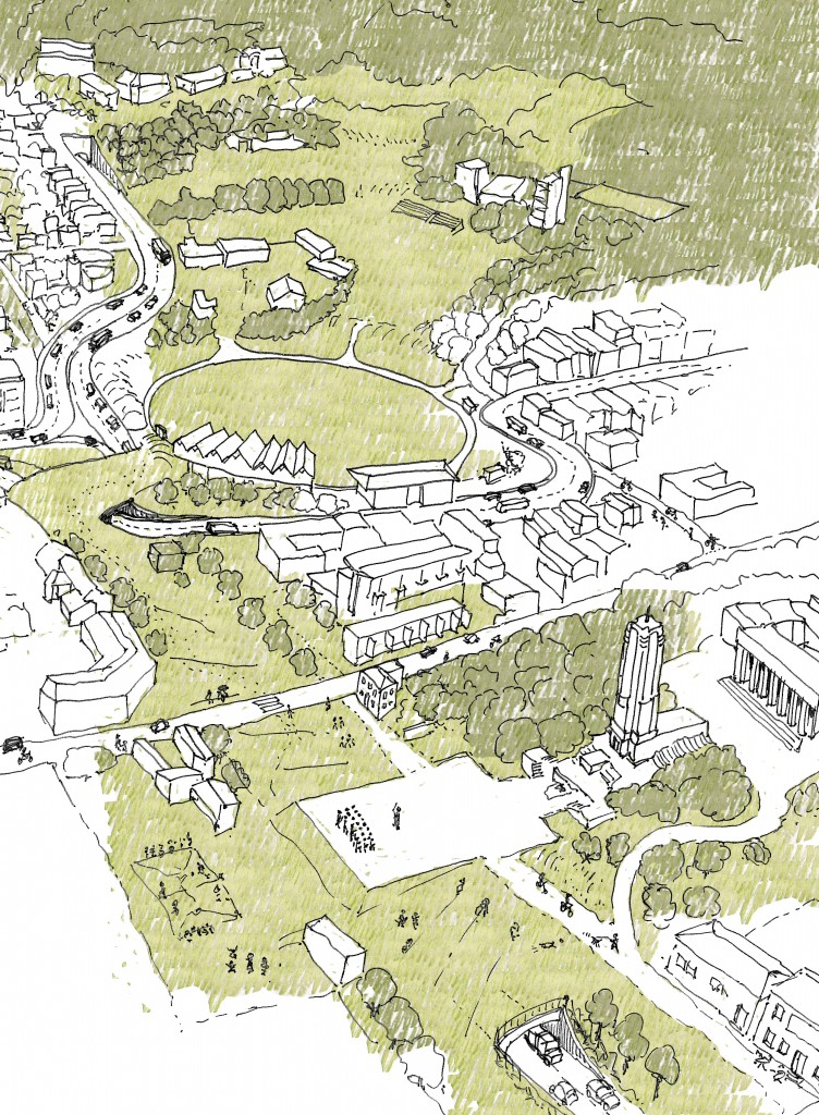
The green south-east quadrant is a connecting park area (from the Basin to Government House) with driveway access to Government House and adjacent schools, as well as accommodation for buses servicing the schools.  This driveway and bus turning is restricted to the south side.  A pedestrian and cycle way continues the historic grid of the Basin on the eastern side.  This will connect the Town Belt walkways into the inner city park through the Basin and Memorial Park.

This can be accommodated within the existing road space, or another option can be seen in the scheme below.

Where is the school drop-off for buses from the eastern suburbs?

The school drop-off for buses from the eastern suburbs is in the south-east quadrant (see above).  Access is through the  Mt Victoria tunnel, turning left around the Basin on Sussex St and direct from Rugby St.  Access from the south-east quadrant and back to the eastern suburbs is made by turning left onto Adelaide Rd and back through Constable St.

How are Government House, the schools and apartments in the south-east quadrant accessed?

Government House, the schools, and apartments are accessed from Rugby St.


MEMORIAL PARK TUNNEL

How do buses from Newtown access the Memorial Park tunnel?

The bus lanes primarily support public transport routes.  Where buses (e.g. school trips) are not following public transport routes they would be able to use other parts of the roading system.  Buses from Newtown to Taranaki Street would access the Memorial Park tunnel using the local road rather than the dedicated bus lanes.

Is an uphill-sloped tunnel a good idea?

The Memorial Park tunnel would have a gradual slope.  The tunnel floor at the north-west corner (Sussex and Buckle Sts corner) would be at about 6 metres above sea level.  The corner of Taranaki and Vivian St is about 17 metres above sea level.  This means a rise of about 11 metres over about 340 metres – giving a gradient of 1:30 or about 3%.  As a comparison, the Mount Victoria tunnel  has a gradient of 1:53 or about 2% (It is 634 metres long, the Paterson St entry is 23 metres above sea level; the Ruabine St entry is 35 metres above sea level). This contour information is available from the WCC at: http://www.wellington.govt.nz/maps/webmaps/webmap/wccmap.html

Where does the Memorial Park tunnel exit?

The proposal suggests that the Memorial Park tunnel exits before Taranaki St, as depicted in the bottom part of the image below.

THE NORTH-WEST CORNER

What happens to the John Swan design Compassion Creche?

An excellent question.  You may have seen on the Option X pdf that detailing of the North-West corner would determine whether the creche would be located in its current position, and any relocation would be under the advice of the NZHPT. This is an important building an early purpose-built creche by a significance architect, and a last remaining remnant of the Catholic community on Buckle St.  It is highly likely that the building would need to be moved during construction to prevent damage.  If the creche is moved it would be moved to a location which retained its current orientation, with a street frontage.

How do the levels work at the north western corner?

Here’s a section through this area to show you.

We have developed the levels using a contour model derived from the contours available from the WCC: http://www.wellington.govt.nz/maps/webmaps/webmap/wccmap.html


TRAFFIC VOLUMES

Is one lane on Adelaide Rd enough? Is one lane from Kent Terrace to Newtown/Island Bay enough?

The number of lanes on Kent and Cambridge Terraces and Adelaide Rd in Option X is the same as the NZTA proposal: one traffic lane and one bus lane.  Roughly the average daily traffic volumes on the State Highway network is 20,000 cars, and on the local roads 10,000 cars.  The information on current volumes is in this pdf from the WCC (basin reserve traffic data).  There is also some information about this at: http://www.nzta.govt.nz/projects/basin-reserve/docs/basin-reserve-scoping-report-06-existing-traffic.pdf


HOW MUCH WILL OPTION X COST?

The Architectural Centre have commissioned Rider Levett Bucknall to provide an independent cost for Option X.  They have estimated that Option X will cost $130-165million.  Option A is estimated to cost $75-100m; Option B $90-120m.  The Rider Levett Bucknall draft report ccan be found here.  We’ll replace this with the final report when we get it.


TRAFFIC ROUTES

How do people from the easterns suburbs access Cambridge Terrace or Tory Street?

People from the eastern suburbs can access Cambridge Terrace one of two ways.  They can travel along the State Highway, which has a reduced number of intersections, to Taranaki St, or they can travel via Constable Street and Adelaide Road to access Tory St (via Rugby and Tasman Sts) or along Sussex St to  Cambridge Tce.

How do cycles/pedestrians travel from east-west?

Yes this is tricky, and something which also depends to some extent on the Mount Victoria tunnel scheme.  The route would be along Dufferin and Ellice Streets to Kent Terrace and then crossing at the pedestrian crossing (see Option X pdf).  We agree that this isn’t completely satisfactory and are working on a better plan.

Why is there no south-to east route?

According to NZTA data (see: http://www.nzta.govt.nz/projects/basin-reserve/docs/basin-reserve-scoping-report-06-existing-traffic.pdf section6.5.1 p. 40) “Very few motorists travel between Adelaide Rd and Mount Victoria Tunnel in either direction.”  They identify that 50% of traffic from Adelaide Rd goes to Cambridge Terrace and 50% goes to the Inner City Bypass.

How does traffic get from Adelaide Rd to SH1 westbound?

Car traffic from Adelaide to Taranaki St and beyond takes the slip lane into the tunnel at the current corner of Sussex Street and Buckle Street.  We’ll redo the diagram to make this clearer as a couple of people have missed this.

What is the pedestrian access from Mt Victoria (Ellice St etc) into the Basin?

Yes we agree that relying on the current route (death by crossing SH1 or a detour to Kent Terrace pedestrian crossing) isn’t the best.  We’ve listened to you and have decided a pedestrian overbridge is the best plan.  We are doing a conceptual design which will work with the existing contours.  Images soon.

What is the pedestrian route from Kent/Cambridge to Adelaide Rd?

The proposal is to have several pedestrian crossings (with traffic lights similar to the current arrangement) at the Buckle St end of Cambridge and Kent Terraces.  The exact placement of these will depend on bus/light rail stops.  These crossings will provide access to the green overbridge and through the Basin to Adelaide Road.  The green overbridge here is important as a pedestrian crossing across SH1 doesn’t make any sense.


Comments

21 responses to “Option X: FAQs”

  1. Not sure about pedestrian crossing access to rail – over-bridge? tunnel?

  2. Anthony – are you talking about the image at the top of the pedestrian crossing? It is a system which is used widely – all over Europe in fact, where Tram lines are quite common in the centre of the road. If there is a really busy station, then of course it would be connected in, without having to cross the road, but this is a system that works well for hundreds of cities with suburban tramlines. No overbridge or tunnel needed.

  3. Peter789 Avatar
    Peter789

    Regarding eastern suburbs access to Cambridge or Tory, a more obvious route is via the Memorial Park tunnel then via Taranaki and back via Vivian or Frederick St. No one from Hataitai is going to drive to town via Newtown!
    For south to east traffic, go round the basin onto Cambridge and then use the existing (or new) u-turn link onto Kent Tce. East to south traffic has the slip road onto Sussex St.
    Three questions for you.
    How do you mitigate having SH1 hard up against the northern boundary of the Basin?
    How does traffic get from Adelaide Rd to SH1 westbound?
    How about a pedestrian / cycle underpass from Ellice St to The southeast zone?

  4. Stephen Avatar
    Stephen

    good points peter789.

  5. Stephen, Peter789, we’ve added in some answers to those questions and published it in the FAQ above, they’re at the end of the list.

  6. peter789 Avatar
    peter789

    How about this idea for a modification to Option X…
    Instead of the green connection from Memorial Park linking to the Basin behind (tradesmen’s entrance) and beside (steep) the RA Vance stand in the North West part of the basin…
    Raise the centre island of Kent Cambride (sloping upwards from say Fyfeshire or Barker), make an green overbridge (a la City To Sea bridge) from Memorial Park to this raised pedestrian “boulevard”, and over the SH1 westbound, and then, raise the northern heritage gates of the Basin up to this level. Then inside the gates would need to slope down to the left and right inside the basin. And in fact the gates could even be moved north and placed over SH1. The dirt from digging the Memorial Park tunnel can be used to create this raised boulevard. And the historic gates/entrance would remain an iconic feature. How about that? Would all that work???

  7. Stephen Avatar
    Stephen

    I think your FAQ on “Is one lane from Kent Terrace to Newtown/Island Bay enough?” is flawed.

    We know from previous discussion here that traffic volumes are based on a Council option that traffic volumes to Newtown / Island Bay will not increase.

    Yet your answer to the question ” How do people from the easterns suburbs access Cambridge Terrace or Tory Street?” is to direct them via Constable Street and Adelaide Road.

    Apart from being a indirect route, this will increase traffic volumes in Newtown on its own.

    And other readers agreed with me previously that other planned developments such as the supermarket in Tasman St and the John St site will increase traffic flow.

  8. Stephen Avatar
    Stephen

    Ooops – Need to add to the above that there will be more traffic in Newtown overtime as more people want to vehicle destinations such as the airport – airport retail centre – aquatic centre – indoor sports centre, etc. While not passing through Option X – it will add more vehicles into Riddiford – Constable sts – adding to blockages.

  9. Peter789 – it would indeed work, and I have thought about that as well. I guess though that at the end of the boulevard of Kent/Cambridge, that it would be nice to see a a route through the trees and buildings into the Basin itself, and beyond to Newtown. That’s why we’re not that keen to build up a hillock / raised boulevard right there, but you’re right, it could be feasible.

  10. Stephen, we hope that it is not flawed – we have had a traffic engineer look at the scheme, and they said that it was a reasonable proposition. We are hoping that NZTA will be able to give Option X a good review and run some modeling figures on it to prove it works.

    I take the route from the Eastern / Southern suburbs to Tory St regularly. Although I can’t give you an exact figure, it would appear that I am one of the few people ever going right down Tory St – it is, honestly, a very underused road. The advantage that we see in putting the tunnel under the Memorial Park, is that it offers the chance to free Tory St up, to remove it from being a chopped-in-half Tasman / Tory route, and instead allow it to blossom as a local road, for local residents, for linking into the growing restaurant and foodie scene going up along Tory St. It will also be able to connect together the communities who live nearby, currently sliced in two by the wide asphalt swathe of Buckle St.

  11. Stephen Avatar
    Stephen

    Guy – I support putting in a tunnel under memorial park.

    The point that I disagree with your design is that traffic volumes to Newtown / Island Bay only warrant one lane through Option X.

    Kent and Cambridge are multi-lane and I believe this should continue through to Adelaide Rd to cater for current and future growth.

    Is is interesting you say the tunnel “will also be able to connect together the communities who live nearby, currently sliced in two by the wide asphalt swathe of Buckle St” – this is reason why I support flyover to connect the OptionX tunnel and Mt Vic or else you are doing the same at the Basin.

  12. Stephen, you’re right that Kent and Cambridge Tce are multi-laned – they need to be, to cope with the State Highway traffic. At present there are multiple lanes which are heavily used fromthe bottom of Vivian St, going down to the Basin. As far as we understand, NZTA’s own traffic modelling has shown that once SH1 traffic and Adelaide Rd traffic are separated, then traffic will flow smoother. Remember that the traffic congestion comes from the stopping and starting associated with traffic lights – not just from the sheer amount of traffic itself. We think that with less traffic lights on the routes, traffic flow will be improved.

  13. David Stevens Avatar
    David Stevens

    Re comment above about pedestrian/cycle access from Mt Vic/Ellice St – have you come up with an idea and location for a pedestrian overbridge? A second Mt Vic tunnel is a long way off (I don’t think it will be needed) so whatever can be done to improve pedestrian/cycle routes around the Basin is likely to have long-term benefits.

  14. David, we’re right with you on that – there definitely needs to be a connection between Mt Vic to the other (south) side of the street, and we are saying as much in our submission to NZTA.
    Here’s the thing: with a overpass such as is being proposed by NZTA, a pedestrian link is likely to be created under, if at all. Pedestrian / cycle underpasses are rarely nice things, and are often smelly and dangerous – have you ever been in the one under the airport in Wellington? Totally awful.
    However, with a road staying at ground level, such as what we are proposing with option X, a bridge can quite easily be incorporated to work with the lie of the land, and swoop out above the traffic. We believe that with careful design this could be a beautiful sculptural object, and a joy to cross, linking the 2 sides of Mt Victoria back together.

  15. Stephen Avatar
    Stephen

    Guy – is your statement correct when you say
    “Pedestrian / cycle underpasses are rarely nice things, and are often smelly and dangerous – have you ever been in the one under the airport in Wellington? Totally awful.”
    It is my understanding that the NZTA flyover is significantly higher and thereforeyour comments are not applicable.

    Also it just occured to me – how to pedestrians / cyclists go from Adelaide to Cambridge tce in your plan given that Salex st is very tight with four lanes and they cannot cross the four lanes of your ground road?.

  16. Stephen, I’m not talking about the Flyover – I’m talking about that small pedestrian underpass linkages are shown on some NZTA plans, which, because they have roads going overhead, naturally then promote footpaths at ground level. There is a small crossing just down by St Joseph’s, which can only cross the State Highway eastbound either at road level or under in a tunnel – and if we assume that SH1 cannot be stopped with a pedestrian crossing then presumably it must be an underpass.

    We have been quite critical of NZTA proposals for not paying enough attention to pedestrian and cycle users. They (NZTA) have produced drawings without a clear pedestrian strategy on, and to be fair, are still in the stage of consulting on – this is an aspect that they really do want feedback on. With Option X, we have tried to keep public transport, pedestrian and cycle routes foremost, and so that is the reason we have introduced the large pedestrian overbridge on the north side. We do not presume that anyone would want to cycle through Sussex St when two comfortable alternatives exist: either from Adelaide to Tory via Rugby and Tasman, or via the Basin Reserve and over the pedestrian overbridge.

  17. albino steve Avatar
    albino steve

    wont the tunnel require extract fans and ducting? If i’m sitting in backed up traffic in a tunnel I would hope so. The 6m you have shown seems optimistic…

  18. Stephen Avatar
    Stephen

    FYI – from meeting with NZTA, we clarified that the crossing near St Joseph’s for the two lanes heading in the eastern direction was at road level rather than being an underpass. The group I was with suggested a broad underpass at street level given the road is rising towards the tunnel entrance

    You are wrong to criticise NZTA for not paying attention to pedestrians and cyclist.
    – They are creating a wide pedestrian and cyclist lane from Cobham Drive all the way to Mt Vic tunnel.
    – The proposed Mt Vic tunnel has a whole lane devoted to pedestrians and cyclist with options for physical separation.

    I agree Transit should have looked at enhancements such as a pedestrian cycle lane on the flyover to link Mt Vic to Mt Cook. Also a St Josephs underpass would enable cyclists to ride from Kent to Adelaide unimpeded and Sussex could be reduce to two lanes so if the NZTA transit plan had a tunnel under Memorial park like option X – this would enable cyclists to have a whole lane to ride south without interruption.

    Re Option X pedestrian cyclist access from Kent to Adelaide thats quite a deviation for north bound Kent Tce travellers to have to cross Kent / Cambridge to get to West side of road to reach the overbridge to the Basin.
    Dont forget – the Rugby / tasman st route is now going past a busy supermarket with vehicles going in and out.

  19. Albino – the tunnel is 8m high in the centre, so adequate room for fans if required. Portals are kept at 6m, and exhaust ventilation shafts, if needed, can rise vertically – very common in tunnel design (obviously not possible under Mt Vic). Probably only 1, possibly 2 tunnel vent shafts would be needed.

    Stephen, I stand corrected on their crossing near St Jo – I’m glad to hear that it is not an underpass. Thanks for that.
    Rugby St supermarket is by no means certain: nothing has been built yet.

    I’m a wee bit concerned though Stephen that you seem to be coming across as though we have no right to offer criticism of the NZTA scheme. Should any community lobby group sit meekly by and accept the view that whatever our political masters say to us, we should accept that? We have examined the NZTA scheme very closely and have also met with them, and we are in doubt that there will be tweaks to their scheme, as there would be to ours. What we are talking about here is the principle of: has the right base scheme been adopted – and can it be improved. We would say: No to the first, and Yes to the second. We stand by our critique.

  20. Stephen Avatar
    Stephen

    I am in no way implying that the Arch Centre should not criticise NZTA – In fact I think it is a good thing.

    Rather I am merely pointing out errors in your statements that could mislead readers e.g.

    – its was wrong to write about a underpass at St Josephs and compare it to the airport tunnel when it was only a presumtpion

    – To say “NZTA have produced drawings without a clear pedestrian strategy” is misleading as they have included cycle lanes even in the new tunnel.

  21. Thanks Stephen – yes I have apologized regarding my presumption that there may be an underpass there – in fact I’m really glad to hear that they don’t so thanks for pointing that out to us.
    I am though still really disappointed at NZTA’s pedestrian and cycling provision – and I wouldn’t necessarily say they have a strategy. At present the cycling provision and pedestrian routes on NZTA schemes is, shall we say, rather flexible and definitely not set in concrete. Part of the issue is that the cycleway is thought of as a Clip On, rather than integral, and integrated.

Leave a Reply

Your email address will not be published. Required fields are marked *